Province de Chiang Rai
Rédigé par Chang Aucun commentaire
Province de Chiang Rai Province de Chiang Rai La Province de Chiang Rai se situe dans la région Nord de la Thaïlande. Province de Chiang Rai - […]
Province de Chiang Rai
La Province de Chiang Rai se situe dans la région Nord de la Thaïlande.
Province de Chiang Rai - Anglais
The city was founded by King Mangrai in 1262 and became the capital of the Mangrai dynasty. However, it lost this status soon after to a new city built by Mangrai at Chiang Mai. Subsequently, Chiang Rai was conquered by Burma and remained under Burmese rule for several hundred years. It was not until 1786 that Chiang Rai became Chiang Mai vassal. After Siam or Thailand annexed Chiang Mai in 1899 Chiang Rai was proclaimed a province of Thailand in 1933.
In 1432 during the reign of King Sam Fang Kaen of Mangrai dynasty (1402-1441) the Phra Kaeo, or Emerald Buddha, The most revered Buddha figure, was discovered in Chiang Rai when an earthquake split the Chedi at Wat Phra Kaeo. The beautiful jade figure was then seen concealed within.
In 1992 (B.E. 2535) the City Pillar was moved from Wat Klang Wiang to Doi Chom Thong, where it is known as Sadu Meuang (TH: สะดือเมือง), the Navel or Omphalos of the City.
Province de Chiang Rai - Traduction
La ville a ete fondee par le roi Mangrai en 1262 et est devenue la capitale de la dinastie des Namgrai. Cependant, elle a perdu son statut peu apres la construction de la nouvelle ville par Mangrai a Chiang Mai. En consequence, Chiang Mai a ete conquise par Burma et modifiee selon les regles de cette administration pendant quelques centaines d'annees. Cela n'est pas alle jusqu'a 1786 date a laquelle Chiang Rai est devenue sous la juridiction de Chiang Mai. Apres que le royaume du Siam ou la Thailande ait annexe Chiang Mai en 1899, Chiang Rai est devenu infeode et a ete proclame province de Thailande en 1933...
En 1432 lors du regne du Roi Sam Fang Kaen de la dinastie Mangrai (1402-1441) le Phra Kaeo, ou Bouddha d'Emeraude, la plus reveree des symboles de Bouddha, a ete decouverte a Chiang Mai lors de tremblements de terre divisant le Chedi a Wat Phra Keo. La belle figure de jade a ete vue dissimulee a l'occasion.
En 1992, la ville de Pillar a ete deplacee depuis Wat Klang Wiang jusqu'a Doi Chom Thong, laquelle connue pour Sadu Meuang, le Nombril ou Omphalos de la ville.
Province de Chiang Rai - Geography
Muang Chiang Rai is 200 km northeast of Muang Chiang Mai, Chiang Mai Province; 62 km south of Mae Sai and the Myanmar border; 60 km southwest of Chiang Saen on the Mae Khong across from the People's Democratic Republic of Laos; and 90 km north of Nakhon Phayao, Phayao Province.
The Mae Kok River runs along its north side, flowing from west to east and eventually merging with the Mekong River.
Province de Chiang Rai - Demographic
Population 62,000.
12.5% of the population belong to the hill tribes, a collective term for the minority ethnic groups in the North of Thailand such as the Karen, Akha, Lisu, Meo and Muser. Many Chinese, particularly from Yunnan Province, have migrated to the area and assimilated with the Thai population to such extent that well over half of the large businesses in northern Thailand are owned by people of Chinese heritage.
Province de Chiang Rai - Government
Chiang Rai is the capital of Chiang Rai Province.
The Salaklang Changwat show location on an interactive map19°54.805′N 99°49.615′E / 19.913417, 99.826917 holds the Provincial Offices.
The Municipal Offices are in the Thesaban show location on an interactive map19°54′34″N 99°49′39″E / 19.90944, 99.8275.
Province de Chiang Rai - Buddhist temples
Wat Phra That Doi Chom Thong, show location on an interactive map19°54.970′N 99°49.365′E / 19.916167, 99.82275
Wat Phra Kaew, Chiang Rai, show location on an interactive map19°54.704′N 99°49.647′E / 19.911733, 99.82745
Wat Phra Sing, Chiang Rai, show location on an interactive map19°54.653′N 99°49.882′E / 19.910883, 99.831367
Wat Doi Khao Khwai, show location on an interactive map19°52.892′N 99°48.582′E / 19.881533, 99.8097
Wat Rong Khun, show location on an interactive map19°49.480′N 99°45.800′E / 19.824667, 99.763333, a modern temple built since 1998 by Thai artist Chalermchai Kositpipat
Province de Chiang Rai - Tourist attractions
Princess Mother Hall and Doi Mae Salong Located about 70 km northwest of Chiang Rai accessed by a scenic, and sometimes quite steep, road from Mae Chan. In Mae Salong there is a museum of the Kuo Min Tang and their plight after exiled from China by Mao Zedong, and subsequently forced to leave Burma from where they entered Thailand, helping at times to fight the Communists.
Doi Tung Royal Villa is the final residence of the mother of the King of Thailand, known as the Princess Mother. It is located at kilometre 12 on highway 1149, to the west of highway 1. This magnificent villa was built on the mountain overlooking the surrounding hills and valleys in a unique mix of Swiss and Lanna architectural styles. Adjacent to the villa is a large flower-filled garden, and a memorial hall commemorating the Princess Mother.
Doi Tung Zoo
Phucheefah
The Gate of Siam is a location on the border with Laos where one can stand high up on a mountain with Laos directly in front and the mighty Mekong River flowing beneath.
Province de Chiang Rai - Cartographie
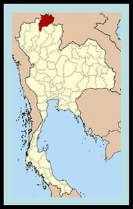
Province de Chiang Rai